Study Guide for Geography Assessment 9/22/17
Be able to label on a map: North Carolina, Atlantic and Pacific Oceans, Mississippi River, Rio Grande River, Great Lakes, Appalachian Mountains, Rocky Mountains, Great Plains, Washington, DC, relative location in NC.
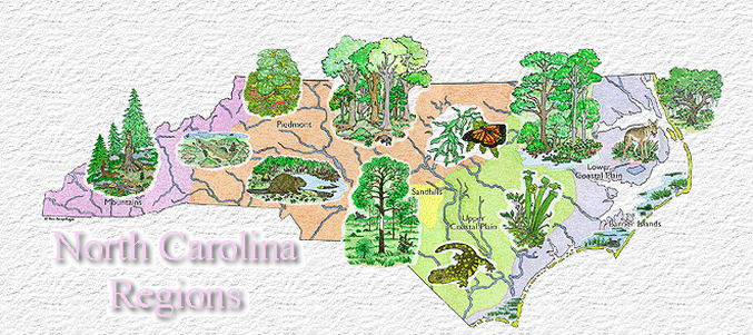
Be able to identify: five themes of geography, characteristics of each of NC's regions, advantages and disadvantages of NC's regions, and definitions of region, relative location, and the themes of geography.
Use your map, graphic organizer on the regions of NC, and other materials to study!!
Be able to label on a map: North Carolina, Atlantic and Pacific Oceans, Mississippi River, Rio Grande River, Great Lakes, Appalachian Mountains, Rocky Mountains, Great Plains, Washington, DC, relative location in NC.
Be able to identify: five themes of geography, characteristics of each of NC's regions, advantages and disadvantages of NC's regions, and definitions of region, relative location, and the themes of geography.
Use your map, graphic organizer on the regions of NC, and other materials to study!!
Friday, September 22, 2017
Quick Review - US and World Geography - Questions?
Quiz - Geography (8.G.1.2 and 8.G.1.3)
_____________________________________________________________________________________________________________________________
Wednesday & Thursday, September 20-21, 2017
(for students NOT attending the Old Stone House Field Trip each day)
You may work on any assignments from these at any point during the day unless instructed by your teachers. Be sure to monitor due dates for these assignments.
Social Studies Assignments:
1. Finish Analysis tool for Immigrants and Migrants of North Carolina (have ready to turn in Friday)
2. In Schoology, complete the PlayPosit video called Immigration in NC. You can rewind before answering and retake if your score is not satisfactory.
3. Complete the assigned article in Achieve 3000: Storm Hits East Coast. You should complete the before and after reading poll, at least one annotation strategy for each paragraph, the activity, and the thought question. This is due Friday as well.
4. Study for Geography Quiz - see study guide at the top of this page!
English Language Arts Assignments
1. Be sure 100 minutes of Membeam are COMPLETE by the end of the day Thursday. There is NO quiz or Mrs. Huntley's classes this week.
2. AOW - Hispanic Heritage due Friday of this week
3. Complete any missing work (check Power School)
4. Read Forged by Fire novel (Mabry)
Science Assignments
Complete your Quicker Picker Up Lab Extension - Mr. Taylor has some on his desk if you need one, but you need to ask
Study Guide for Friday's test (Check Faggart or Taylor's website)
Math Assignments
Taylor - IXL F16 and any make up work that is posted in Power School. You should also have finished IXL D5.
__________________________________________________________________________________________________________
Tuesday, September 19, 2017
ON TUESDAY, DO THIS FIRST IN HOMEROOM ONLY!!
RED Time Options
Link To Sign Up docs.google.com/forms/d/e/1FAIpQLSfeGEAqKQoBEtWaYdu9xLN5tTJ00_L8BAgSRNwA7MOs6_G25g/viewform
Big Question: What groups have shaped the human geography of North Carolina? How has North Carolina been influenced by immigrants and emigrants?
Using the provided resources, students will complete the document analysis tool.
North Carolina, a New Immigrant Destination
http://immigrationforum.org/blog/north-carolina-a-new-immigrant-destination/
Immigrants in North Carolina: A Fact Sheet
http://sogpubs.unc.edu/electronicversions/pg/pgfal08/article4.pdf
Map
https://www.brookings.edu/wp-content/uploads/2016/06/1013_immigration_wilson_singer.pdf
BTC Brief - DACA's influence on North Carolina
World Design Challenge Maps w/comments and grades returned; grades posted in Power School by Tuesday
Monday, September 18, 2017
Big Question: What groups have shaped the human geography of North Carolina? How has North Carolina been influenced by immigrants and emigrants?
Video Introduction
Using the provided resources, students will complete the document analysis tool.
North Carolina, a New Immigrant Destination
http://immigrationforum.org/blog/north-carolina-a-new-immigrant-destination/
Immigrants in North Carolina: A Fact Sheet
http://sogpubs.unc.edu/electronicversions/pg/pgfal08/article4.pdf
Map
https://www.brookings.edu/wp-content/uploads/2016/06/1013_immigration_wilson_singer.pdf
BTC Brief - DACA's influence on North Carolina
World Design Challenge Maps w/comments and grades returned; grades posted in Power School by Tuesday
Friday, September 15, 2017
Big Question: Are the Outer Banks a safe and sustainable location for citizens to live?
The Outer Banks - Are the islands disappearing or reforming? What do you think?
New Island Emerges off the North Carolina coast
What if your home was slipping into the ocean?
Outer Banks national seashores could lose $2 billion to rising seas
North Carolina Sea Level: No more head-in-the-sand?
Images Link - National Geographic
Objective: You are going to assume the role of a geographer to help determine whether or not the state of North Carolina should encourage citizens to move to the Outer Banks or not based on evidence from numerous sources.
You will write a persuasive paragraph (4-6 sentences) that describes one possible perspective.
You should include evidence that supports OR opposes the following statement:
The Outer Banks are a safe and sustainable location for citizens to live.
As you go through the sources above, you should create a t-chart graphic organizer that shows supporting and opposing evidence from each. This doesn't need to be in complete sentences, bulleted notes are fine.
Once you have collected your evidence, you will write a paragraph to support your position. Your objective is to persuade me to support you, so keep this in mind for your writing purpose.
Thursday, September 14, 2017
North Carolina's Three Regions - How well do you know our state?
Application & Review of what you learned through the investigation of the three regions.
Together, we will go through a series of review questions about North Carolina's geography. These are not simple
recall, but application of what you have learned.
North Carolina's Geography Review
Wednesday, September 13, 2017
Because many students were not using time well, this assignment has carried over to Wednesday's class from yesterday. Please note, if you are using the digitally available answer key to copy your answers, this is NOT acceptable. The Regions graphic organizer should be considered homework this evening for my classes.
1. North Carolina's Three Regions: A Deeper Investigation (you may work with ONE partner on this activity only)
On the back of your physical United States map, you are going to individually investigate the regions of our state. In each of the columns, you will record information you collect for each of the regions based on the characteristics provided.
Use the links below to help you with this information. You will need to use multiple tabs/pages to help you find all of the required information. You can use additional sources as needed to help you. Provide as many details in each segment as possible.
Link One: North Carolina Regions - LiveBinder
Link Two: NC Geography LiveBinder
Link Three: North Carolina's Three Regions
2. TURN IN - In the basket at the FRONT of the room, turn in your US Physical Features Map with the NC Regions Graphic Organizer on the back. MAKE SURE YOUR NAME IS ON IT. Also, turn in your graphic organizer for the five regions of the United States. These should be turned in by the end of class TODAY.
3. Use Clever to login to Achieve 3000. There has been an article assigned in your Social Studies course that is called "Storm Hits East Coast." You need to complete the Before Reading Poll, a minimum of ONE Reading Strategy for EACH paragraph, the Activity, After Reading Poll, and Thought Question. This COMPLETED article in A3K is DUE Friday, September 15th. This is an INDIVIDUAL assignment and should be completed quietly on your own.
Tuesday, September 12, 2017
I am sorry I am not here today to help guide you through your investigation of North Carolina. I was called to a teacher training. Please read through the directions and make sure you COMPLETE EACH STEP as directed.
1. North Carolina's Three Regions: A Deeper Investigation (you may work with ONE partner on this activity only)
On the back of your physical United States map, you are going to individually investigate the regions of our state. In each of the columns, you will record information you collect for each of the regions based on the characteristics provided.
Use the links below to help you with this information. You will need to use multiple tabs/pages to help you find all of the required information. You can use additional sources as needed to help you. Provide as many details in each segment as possible.
Link One: North Carolina Regions - LiveBinder
Link Two: NC Geography LiveBinder
Link Three: North Carolina's Three Regions
2. TURN IN - In the basket at the FRONT of the room, turn in your US Physical Features Map with the NC Regions Graphic Organizer on the back. MAKE SURE YOUR NAME IS ON IT. Also, turn in your graphic organizer for the five regions of the United States. These should be turned in by the end of class TODAY.
3. Use Clever to login to Achieve 3000. There has been an article assigned in your Social Studies course that is called "Storm Hits East Coast." You need to complete the Before Reading Poll, a minimum of ONE Reading Strategy for EACH paragraph, the Activity, After Reading Poll, and Thought Question. This COMPLETED article in A3K is DUE Friday, September 15th. This is an INDIVIDUAL assignment and should be completed quietly on your own.
Monday, September 11, 2017
North Carolina's Place in the United States:
Essential Questions: What physical characteristics make North Carolina unique? How does North Carolina fit in the United States? How does North Carolina compare to our neighboring states? Do we fit in the region we are a part of? Why or why not?
Individual Practice: Labeling maps with appropriate physical features to determine characteristics of a region.
Directions:
1. On the physical map of the United States, label the physical features (mountains, rivers, lakes, plateaus, plains, etc.). Be fairly detailed as we will use this information to answer our essential questions.
2. On notebook paper, create a 5 column chart. Label each of the five columns with one of the regions. In each column, list the physical characteristics that define the region. That is, what characteristics are there that would define it as a region.
3. Now, think about our state of North Carolina and where it is located in the United States. If we took the state of North Carolina and put it in another region, what physical characteristics would define it as a state within that region? Finally, do some more research. Find out 3 additional facts that would make the way of life for North Carolinians different should it be moved to another region in the United States. Use the links below to help you do research on the regions of the United States.
Link One: The Regions of the United States
Link Two: Traditional Regions of the United States
Link Three: Regions of the United States Detailed Map
4. Answer these question in the Discussion Post in Schoology. This should be completed BEFORE you leave class today.
Friday, September 8, 2017
Benchmark -
One of the key indicators that we use throughout the year to measure progress in your learning is to use benchmark testing each quarter. In Social Studies, we start with a pretest to determine what is already prior knowledge to compare over time to what you have learned.
The exam is NOT taken as an assessment grade, however, it is expected that you do your best. I will use these benchmarks to determine who needs additional assistance throughout our start of RED time in late September.
*. Some students will be asked to complete the additional surveys for Mrs. Mills.
Complete and turn in mind map. Remember, while this is an assessment, I am looking for what you know about US history. There is not requirement for space, amount of information, or artistic expectations.
Complete and KEEP your US Physical Features Map. On this map, you should label things like mountains, rivers, lakes, plateaus, plains, etc. This does NOT have to be colored.
Thursday, September 7, 2017
Design Challenge Round Two
As a group, you need to consider the comments from the peer evaluation provided. How can you improve your design challenge based on the rubric?
Your second submission is due TODAY at the end of class. This is your final submission, so take care in how you repair your initial map or create a new one. Think about the basic elements of the map.
Wednesday, September 6, 2017
Warm Up -
1. Click HERE to vote on the classroom rules/expectations as created by your classmates.
2. Complete the survey for YOUR class with Mrs. Mills by clicking the link below. These are NOT related to our class, but will be used for Mrs. Mills Master's Program. Your answers will be anonymous.
First Period - Survey
Third Period - Survey
Fourth Period - Survey
Fifth Period - Survey
Self and Peer Assessment -
First, you will assess another group's map from another class using the teacher created rubric. Be careful of the points you give based on the requirements, if it's not complete, don't give the points. You will NOT grade this group based on teamwork/collaboration.
Discussion - How does this map compare to yours? What about grading? Did you your group meet the expectations you set forth before creating?
Tuesday, September 5, 2017
Design Challenge: The World As You See It
You will collaborate with your peers to create a map of the world that is flat with 3D features suitable for teaching lower elementary students about world geography. Your map must be created using only the materials provided in your "mystery bag" as well as glue, tape, and scissors.
*. Remember, your groups MUST create a rubric that describes how you will assess yourselves as well as your peers. Your rubric point value should be 33 points in groups of 3 and 50 points in groups of 2. Your final grade will be a combined score of the rubrics from yourself and your peers.
Tentative Due Date: Tuesday, September 5th at the end of class
Monday, September 4, 2017
Labor Day Holiday
Friday, September 1, 2017
Design Challenge: The World As You See It
You will collaborate with your peers to create a map of the world that is flat with 3D features suitable for teaching lower elementary students about world geography. Your map must be created using only the materials provided in your "mystery bag" as well as glue, tape, and scissors.
*. Remember, your groups MUST create a rubric that describes how you will assess yourselves as well as your peers. Your rubric point value should be 33 points in groups of 3 and 50 points in groups of 2. Your final grade will be a combined score of the rubrics from yourself and your peers.
Tentative Due Date: Tuesday, September 5th at the end of class
Thursday, August 31, 2017
Design Challenge: The World As You See It
You will collaborate with your peers to create a map of the world that is flat with 3D features suitable for teaching lower elementary students about world geography. Your map must be created using only the materials provided in your "mystery bag" as well as glue, tape, and scissors.
*. Remember, your groups MUST create a rubric that describes how you will assess yourselves as well as your peers. Your rubric point value should be 33 points in groups of 3 and 50 points in groups of 2. Your final grade will be a combined score of the rubrics from yourself and your peers.
Tentative Due Date: Tuesday, September 5th at the end of class
Wednesday, August 30, 2017
Sit with your classmate groups for document analysis. Today you should wrap up your analysis, annotation of the texts, and creation of your rules for classroom expectations. We will vote next week on the rules as a grade level.
Once your group has finished these tasks, you may begin your mind map on what you know about US history. Remember, this is just for me to get an idea of what you are familiar with in our content, not a formal assessment.
This will be due Friday, September 8.
Tuesday, August 29, 2017
Warm Up - At your table, come up with up to 10 synonym and antonyms for the word rule. Think about the word in multiple contexts.
Table Talk Part Two: In small groups, discuss your family expectations and rules from your homework. Everyone should participate, but there is NO need to record your responses.
Class Government - We will use primary documents to help us determine rules that have stood the test of time and can be used in our classroom expectations. In small groups, you will complete the analysis of the document and create TWO rules based on the documents.
Monday, August 28, 2017
Welcome and Introductions
Basic Procedures
Restrooms, iPads, supplies, movement, seating
Index Cards - Student Information
Class Government - Are rules necessary? How can we create rules for our classroom using historical documents?
Google Slides - Guided Discussion and Questioning for Documents
Homework - Discuss with your family members expectations and rules for your family. Record five expectations or rules as well as some consequences or rewards. Write them on notebook paper to be shared with small groups tomorrow.
